
Old Maps and Globes > Holy Land Maps
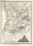
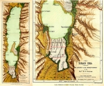
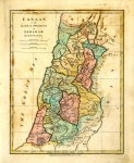
Ancient Palestin John Teesdale 1841 w/ Inset of Jerusalem
Item#: MAH946
SOLD

This map is by drawn and Engraved by John Dower of london and published by Henry Teesdale, in 1841. This is a handcoloured map from Teesdale's New General Atlas of The World. Teesdale's atlas is one of the finest of it's time with handcolouring, the signature piano key border, and excellent detail. The map depicts the Holy land with the borders of the 12 tribes in color. The inset of Jerusalem shows Jerusalem during the Second Temple Period. The map is in excellent condition with no foxing, spotting, rips or tears The map measures approx 18" x 14.5", (46 cm x 37 cm).
Related Items
-
 Price: $55.00
 -
 Price: Contact us
 -
 Price: $250.00
Development: Epoch | Design: Luch
Copyright © 1999-2024 Gilai Collectibles. All Rights Reserved