
Old Maps and Globes > Holy Land Maps
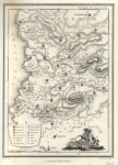
Wilkinson Map of Canaan or the Land of Promise 1807.


This map was published in 1807. It is copperplate engraving printed on heavy paper with original hand coloring. The map depicts a plan of the land of Israel at the time of Abraham and the Patriarchs. It shows the different divisions according to the different nations who lived there at the time: Jebusites, Amorites, Hittites, canaanites etc. Also depicted are the major cities and towns as well as rivers wadis and mountains. Robert Wilkinson who worked from 58 Cornhill Street in London published the map in his ‘Atlas Classica’ in the year 1807. This atlas contains a section with collection of maps of countries mentioned by ancient authors, both sacred and profane under the name ‘Geographia sacra’. This map has the following information at the bottom boarder: "London, Published September 7th, 1798, by R. Wilkinson, No. 38 Cornhill." A similar map from the same date (1798) could be found in the ‘Laor Collection’. The map image measures approximately 22 X 28 cm (9 by 11 inches) on a 26 X33 cm (10 1/2 by 13") page as seen in the pic.
the map is in very good condition
the map is in very good condition
Related Items
-
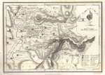
 Price: $120.00
 -
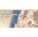
 Price: $55.00
 -
 Price: $55.00
Development: Epoch | Design: Luch
Copyright © 1999-2024 Gilai Collectibles. All Rights Reserved