
Old Maps and Globes > Holy Land Maps
Map Of The Land Of Israel 1945, By Zalman Lifschitz.
Item#: MAH1081
SOLD


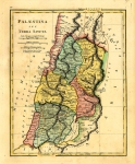
A Large Hebrew Map Of The Land Of Israel 1945, By Zalman Lifschitz. A geographic map in color, compiled according to written documentation, special exploration and surveys. This is the ‘northern sheet’, which encompasses the Lebanon from Tyre to the Negev just south of the Dead Sea. In this important map, all place names of towns, villages, mountains, lakes, etc, are in Hebrew. Also included are roads, train tracks streams and archeological tells. First printed in 1936, this is a revised 1945 version. Printed by ILDC (Israel Land Development Company- Hachsharat HaYeshuv). Size: 73 X 105 cm (29 X 41 inch). Scale: 1:250,000.
Related Items
-
 Price: Contact us
 -
 Price: $44.00
 -
 Price: $200.00
Development: Epoch | Design: Luch
Copyright © 1999-2024 Gilai Collectibles. All Rights Reserved