
Old Maps and Globes > Holy Land Maps
Map of Palestine 1862. Published by Johnson and Ward U.S.A.
Item#: MAH1082
SOLD

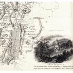
Johnson's map of Palestine. Published by Johnson and Ward. Year Published: 1862. Production Place: USA. Size (width X Height): 13 X 15 ½ inch. Method and Color: Steel engraving with full original hand color and decorative borders. Map Description: This famous map shows the territories of the 12 tribes of Israel that were aligned on both banks of the river Jordan, and emphasizes Jewish Biblical settlements, territories and districts. The regions are individually hand-colored, and the place names are given in scriptural, classical, and modern terminology. The ancient Roman divisions: Judea, Samaria, Galilee, Phoenicia (Present Day Lebanon), Perea (Present Day Jordan) are delineated. Inset Description: Vignette view of Damascus Syria and an inset city plan of Jerusalem at bottom right. Map Source: New Illustrated Family Atlas, published in 1862, USA.
Related Items
-
 Price: $65.00
 -
 Price: $150.00
 -
 Price: $350.00
Development: Epoch | Design: Luch
Copyright © 1999-2024 Gilai Collectibles. All Rights Reserved