
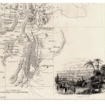
Old Maps and Globes > Holy Land Maps
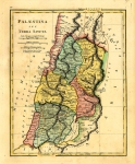
Geological Map of Palestine South of Bethel. Published in London by John Murray 1883.


Geological map of Palestine South of Bethel. Engraved by Stanford's Geographical Establshment published in 1883 London by John Murray of Albermarle St. London and printed by Bradbury, Agnew & Co., Whitefriars, London (from Sinai and Palestine by AP Stanley DD). A small map of the southern part of Palestine showing the different terrains and soils. (limestone, gravel,sandstone etc.) Also depicted are the major towns and cities, such as Jerusalem, Jericho, Hebron and more. Size :12 X 19 cm (5 X 7.5 inches) No foxing, no folds, one very small tear to top left corner.
Related Items
-
 Price: $65.00
 -
 Price: $200.00
 -
 Price: $450.00
Development: Epoch | Design: Luch
Copyright © 1999-2024 Gilai Collectibles. All Rights Reserved