
Old Maps and Globes > Jerusalem Maps
A Set of 13 Maps of Jerusalem, Providing An Accurate Historical Account of the City.1973
Item#: MAJ376
SOLD

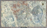
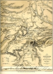
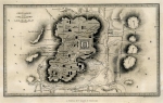
The most accurate educational atlas of Jerusalem ever produced by outstanding scientists. This atlas summarizes the knowledge of two centuries of archeological, historical and biblical research. It is a result of a joint effort by a team of the best researchers from: The Israel Academy of Sciences and Humanities, The Israel Exploration Society, The Hebrew University of Jerusalem. Prof. M. Avi-Yona prepared the bilingual maps. Cartographic work: Walters-Noordhoff, Groningen. Published by W. de Gruyter & Massada In 1973. The atlas includes the following original maps: 1. City of David (Jebus). 2. Period of King Solomon and Hezekiah. 3. Time of Nehemiah. 4. Early Hasmonaean period. 5. Late Hasmonaean period. 6. Time of king Herod. 7. First century A.D. 8. Period of Aelia Capitolina. 9. The Byzantine period. 10. Arab period. 11. Crusader period. 12. Mameluke period. 13. Ottoman period. Scale in all maps: 1:10,000. Size (W X H): 6 inch X 8 ½ inch. Each map is matted separately
Related Items
-
 Price: $250.00
 -
 Price: $60.00
 -
 Price: $50.00
Development: Epoch | Design: Luch
Copyright © 1999-2024 Gilai Collectibles. All Rights Reserved