
Old Maps and Globes > Jerusalem Maps
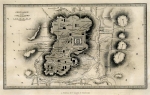
Jerusalem – The Old City. Archeological and Ancient Sites Published by: W. de Gruyter and Massada 1973
Item#: MAJ377
SOLD

Jerusalem – The old city. Cartographic production: Walters-Noordhoff, Groningen. Published by: W. de Gruyter & Massada. Year Published: 1973. Production Place: Israel. Size (width X height): 12 inch X 17 inch. Color and Method: Original Color Print. Scale 1:4000. Map Description: Detailed English and Hebrew description of archeological and ancient sites in the old city of Jerusalem. This is a graphical summary of all the important excavations and findings until 1967, printed on a large scale map. Index and Explanations: Color index of ancient buildings, archeological excavations, ancient pools, sites of special interests etc. Condition of map: Mint. Map Source and Reference: Atlas of Jerusalem (map # 5.29), de Gruyter & Massada, 1973. The atlas is a result of a joint effort by a team of the best scientists from The Israel Academy of Sciences and Humanities, The Israel Exploration Society, The Hebrew University of Jerusalem.
Related Items
-
 Price: $50.00
 -
 Price: $350.00
 -
 Price: $76.00
Development: Epoch | Design: Luch
Copyright © 1999-2024 Gilai Collectibles. All Rights Reserved