
Old Maps and Globes > Jerusalem Maps
George Cram Map of Jerusalem 1899.
Item#: MAJ253
SOLD

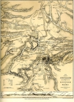
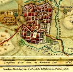
A Detailed Map of Jerusalem. Published by George F. Cram. Year Printed: 1899. Size (width X height): 12 inch X 9 ½ inch. Method: Lithography, printed in color. Map Description: This detailed map shows the two most important building projects in Jerusalem during to the 1860’s: the Russian Establishment near Jaffa Gate (started 1860, inaugurated 1872), and the Jewish cottages (Montefiory) (started 1855 inaugurated 1860). The city within the walls is divided into 5 parts: Moriah (the Temple Mount), Mohammedan, Jewish, Christian and Armenian Quarters. (The population of Jerusalem during the 1860’s totals approximately 11,000 Jews, 6000 Arabs and 2000 Christians). Map Reference: Charles W. Wilson, ‘Ordnance Survey of Jerusalem in the years 1864 – 1865’. Southampton 1866. Map Source: Cram's Home Knowledge Atlas: Geographical, Astronomical, Historical . Published in 1899.
Related Items
-
 Price: $60.00
 -
 Price: $350.00
 -
 Price: $50.00
Development: Epoch | Design: Luch
Copyright © 1999-2024 Gilai Collectibles. All Rights Reserved