
Old Maps and Globes > Holy Land Maps
Palestine Photo Relief Map 1905 Based on a Model by the Palestine Exploration Fund
Item#: MAH1004
SOLD


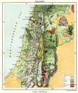
This is a photograph of a relief which was built by Gerorge Armstrong for the Palestine Exploration Fund. It is based on the surveys made by Major Conder and Colonel Sir H, Kitchener, which were made for the Palestine Exploration Fund. The map shows the main cities and the main rivers in the holy land. The map is from the book Biblical Geography & History by Charles Foster Kent NY published in1911. The map itself is dated 1905. Size 33 X 18 cm (13 X 7 inches)
Related Items
-
 Price: $44.00
 -
 Price: $350.00
 -
 Price: $44.00
Development: Epoch | Design: Luch
Copyright © 1999-2024 Gilai Collectibles. All Rights Reserved