
Old Maps and Globes > Jerusalem Maps
Map of Jerusalem and the Surrounding Country from Bethlehem to Bethel by Samuel Clark, 1868
Item#: MAJ256
SOLD


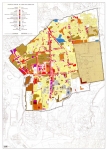
This map was taken from a Bible Atlas to Illustrate the Geography and Topography of the Old and New Testaments and the Apocrypha by Samuel Clark 1868. Published by the Society for Promoting Christian Knowledge. A unique map showing the the vicinty of the city of Jerusalem. The map encompasses a radius of between 8 and 16 km (5 and 10 miles) around the city. Jerusalem is visible near the middle of the map. Depicted on the map are mountain ranges, rivers, roads and towns; both biblical and local. Famous sites which can be seen are Bethany, Mizpeh, Rachel's Tomb, Bethlehem and many more. The bottom part depicts a cross-section through the area entitled: Comparitive view of the heights. Page size 21 X 28 cm (8 X 11 inches)
Related Items
-
 Price: $65.00
 -
 Price: $350.00
 -
 Price: $50.00
Development: Epoch | Design: Luch
Copyright © 1999-2024 Gilai Collectibles. All Rights Reserved