
Old Maps and Globes > Jerusalem Maps
Map of Ancient Jerusalem By Phillips & Hunt 1886.
Item#: MAJ251
SOLD

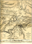
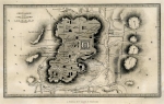
Map of Ancient Jerusalem By Phillips & Hunt 1886. A color map, which was published in The People’s Atlas. Depicted are, the Walled city in ancient biblical times and during Roman Empire after King Herod, showing the Temple on mount Moriah, the upper and lower cities, Calvary Hill, Via Dolorosa, Harrods Palace and much more.On the back is a table of the Chronology of Jewish and Contemporaneous History Map size is 19X27 cm (7.5X10.5 inches). It is in very good condition, only very slight yellowing do to age.
Related Items
-
 Price: $60.00
 -
 Price: $50.00
 -
 Price: $250.00
Development: Epoch | Design: Luch
Copyright © 1999-2024 Gilai Collectibles. All Rights Reserved