
Old Maps and Globes > Jerusalem Maps
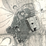
Thomson Map of Jerusalem 1859. Published by Mackanzie, London.
Item#: MAJ1092
SOLD


Plan of Jerusalem and its Environs. Drawn by W.M. Thomson. Published by William Mackanzie, London, Edinburgh, and Glasgow. Year Printed: 1859 in New York. Size (width X height): 11 ½ X 9 inch. Method and Color: Steel Engraved, hand water-colored. Map Description: The American missionary Dr. Thomson who escorted Robinson in his research, drew this important map. The map extends from the valley of Kidron in the north through the Hill of the Evil Counsel in the south. Inside the city walls, major gates, quarters, streets and the holy places are marked. Outside, major graves and cemeteries are indicated. This map was drawn before modern buildings were constructed outside the city walls. (The population during the 1850’s totals approximately 7,000 Jews, 5000 Arabs and 3000 Christians). Map Source: Thomson, W.M., The Land and The Book, etc…New York, London 1859.
Related Items
-
 Price: Contact us
 -
 Price: $65.00
 -
 Price: $76.00
Development: Epoch | Design: Luch
Copyright © 1999-2024 Gilai Collectibles. All Rights Reserved