
Old Maps and Globes > Holy Land Maps
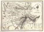
Map of Palestine – Biblical and Modern 1898. Engraved and Published by Bartholomew, Edinburgh.
Item#: MAH1078
SOLD

Palestine – Biblical and Modern. Engraved and published by the Scottish cartographer John George Bartholomew from the Edinburgh Geographical Institute. Year Printed: 1898. Size (width X Height): 14 X 18 inch. Printed in colors on heavy paper. Map Description: The map shows the Holy Land extending from the Mediterranean Sea on the West through the Hauran on the East, and from Edom in the South to Damascus in the North. The map emphasizes Jewish settlements of Biblical origin, modern towns and villages, main roads, the railway from Jaffa to Jerusalem and from Haifa to Damascus. The map is reduced from the Palestine Exploration Fund’s Survey of Palestine. Inset: Jerusalem and its environs. Reference to coloring contours showing height of land in feet (range –2500 ft to +3000 ft). Scale of 11 miles to an Inch. Map Source: The Citizen’s Atlas, Edinburgh.
Related Items
-
 Price: $55.00
 -
 Price: $65.00
 -
 Price: $120.00
Development: Epoch | Design: Luch
Copyright © 1999-2024 Gilai Collectibles. All Rights Reserved