
Old Maps and Globes > Jerusalem Maps
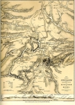
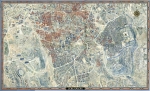
Van de Velde Map of Jerusalem 1858.
Item#: MAJ1011
SOLD


This plan of the town and environs of Jerusalem is very rare and important. It is one of the earliest cartographic maps of Jerusalem and forms the basis for many many further maps. The map depicts streets, houses, water pools, sacred buildings and locations, wadis and mountains. The precision is remarkable. The scale is 1: 4843. Van de Velde used in his maps measurements taken by the English Ordinance survey and by Dr. T. Tobler as well as his own. Carel Willem Meredith Van de Velde (1818-1898) was trained as a naval officer, where he received drawing lessons from Petrus Johannes Schotel (1808-1865), one of the best known Dutch naval artists of the 19th century. He was stationed in Batavia (Java) between 1839 and 1841. Van de Velde made two explorations to the Holy Land one in 1851 and one in 1861. His cartographic expertise was second to none. He produced maps in very high quality that were and are considered the best maps of the area until the British PEF (Palestine Exploration Fund) published their maps (in the 1880s). The map is in excellent condition. No tears cracks or rips no foxing. There is only slight yellowing of the heavy paper. Size 63 X 88 cm (25 X 34.5 inches)
Related Items
-
 Price: $65.00
 -
 Price: $60.00
 -
 Price: $250.00
Development: Epoch | Design: Luch
Copyright © 1999-2024 Gilai Collectibles. All Rights Reserved