
Old Maps and Globes > Holy Land Maps
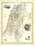
Map Of Palestina Antiqua, London 1826. With Biblical Jewish Settlements, Tribes and Romans Divisions.
Item#: MAH49
SOLD

Palestine during the time of the Romans with a Jerusalem map Insert. Drawn and engraved by Sidney Hall and published, in London 1826 By Longman, Rees, Orme, Brown & Green. Original hand coloring. The map shows the ancient Roman divisions: Judea, Samaria, Galilee, Phoenicia (Present Day Lebanon), Perea (Present Day Jordan) and Decapolis (Present Day Syria), are delineated, as well as the twelve tribes. Biblical Jewish settlements and Roman towns and villages are emphasized, the names of which are mostly in Latin. In the right corner is an insert of Jerusalem during this Second Temple Period. The scales used for this map are Roman Miles or Persian Parasangs. Since the map is from the early 19th century it is clearly visible that the measurements taken then, were not accurate. This can clearly be seen in the shape and size of the Sea of Galilee and the Dead Sea. The Longman Company was founded by Thomas Longman. (1699-1755). In 1824, the title of the firm was changed to Longman, Hurst, Rees, Orme, Brown & Green. Sidney Hall was a drawer and engraver of maps who flourished in London between 1817 and 1860). Minor foxing. Size: 20 X 26 cm
Related Items
-
 Price: $450.00
 -
 Price: $350.00
 -
 Price: $120.00
Development: Epoch | Design: Luch
Copyright © 1999-2024 Gilai Collectibles. All Rights Reserved