
Old Maps and Globes > Holy Land Maps
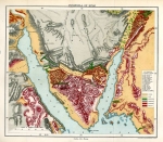
Jewish Settlements in Eretz Israel Prior to The First World War 1915.
Item#: MAH367
SOLD

This is an original map with Hebrew inscriptions, steel engraved and printed in color. The map was published in 1915 by A. Landa, engraved by Z. Elkind and printed by ‘Verlag Buchhandlung Jeruschalmi Jerusalem (Palestina)’. This is a historicaly important combination type map that shows political features like borders, cities, villages and settlements together with geographical features such as mountains, rivers, lakes and shoreline in Eretz Israel (Land of Israel). The sources for the Landa map were: a) the geography book and map “Tvuot Haaretz” by Rabbi Joseph Schwarz (1805-1865). b) The publications and maps by Conrad Schick (1822 – 1901) and c) Cartographic descriptions by Pinhas Halevi Ish Horowitz who published in 1908 a large map of Palestine and Syria.
Related Items
-
 Price: $44.00
 -
 Price: $200.00
 -
 Price: $250.00
Development: Epoch | Design: Luch
Copyright © 1999-2024 Gilai Collectibles. All Rights Reserved