
Old Maps and Globes > Holy Land Maps
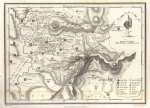
Topographic Map of Jerusalem Environs. Published in 1949 by the British Survey of Palestine.


Published on July 1949. This map is referred to as 1:100,000 Palestine, sheet No. 10 Jerusalem, with topographic contour intervals of 25 meters. Compiled from large-scale surveys 1924-1934. Partially revised & reprinted by the British survey of Palestine, April 1945. Printed by the Surveying Department, Jaffa.
Related Items
-
 Price: $55.00
 -
 Price: $44.00
 -
 Price: $350.00
Development: Epoch | Design: Luch
Copyright © 1999-2024 Gilai Collectibles. All Rights Reserved