
Old Maps and Globes > Jerusalem Maps
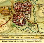
Map of Jerusalem 1866. Published by Harper & Brothers, New York
Item#: MAH1098
SOLD

'Jerusalem’. Publisher: Harper & Brothers. Year Published: 1866. Size (width X height): 9 inch X 6 ½ inch. Method: Printed in color. Map Description: This detailed colorful map was part of Harper’s Hand Book and shows the two most important building projects in Jerusalem during to the 1860’s: a. The Russian Property Complex (started 1860, inaugurated 1872). b. Montefiore Cottages (started 1855 inaugurated 1860). In addition is a list of 34 most important sites of the city. The map serves as an interesting portrait of how Jerusalem looked over 130 years ago. Map Source: Harper's Handbook for Travelers in Europe and The East. By W. Pembroke Fetridge (New York: Harper & Brothers Publishers, 1866) Map Reference: Charles W. Wilson, ‘Ordnance Survey of Jerusalem in the years 1864 – 1865’. Southampton 1866.
Related Items
-
 Price: $65.00
 -
 Price: $350.00
 -
 Price: $250.00
Development: Epoch | Design: Luch
Copyright © 1999-2024 Gilai Collectibles. All Rights Reserved